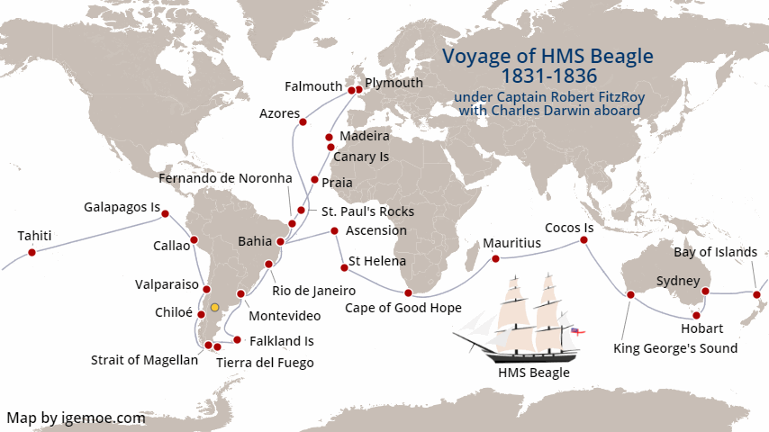
Charles Darwin’s Voyage Aboard HMS Beagle – a Story Map by Igemoe
At Igemoe we like making maps that tell stories. Our short form, animated, story maps are intended as fun maps that tell the story of remarkable voyages. We hope you enjoy them and find inspiration. Here’s our take on naturalist Charles Darwin’s life changing voyage aboard HMS Beagle.
A Little Background to the Voyage of HMS Beagle 1831 – 1836
In 1831 HMS Beagle set sail on her second survey expedition under the command of Captain Robert Fitzroy. Aboard was the young naturalist and amateur geologist Charles Darwin. While the principle purpose of the expedition was to continue the survey of the coasts of southern South America the voyage afforded Darwin the opportunity of a lifetime to study and collect all manner of plants and animals and consider the geology of the places he visited against the current thinking of the time.
Our Darwin & the Beagle Map highlights some of the events that formed Darwin’s thinking on this extraordinary journey that gave rise to his theory of evolution and eventual publication of “The Origin of Species”.
The Ship – HMS Beagle
HMS Beagle was launched on 11th May 1820 from Woolwich Naval Dockyard on the River Thames. She was a 10 gun brig of 27.5 meters but as there was no immediate active use for her she was repurposed as a survey vessel and in this capacity made three far reaching expeditions. While most famous as the ship that carried Charles Darwin on his voyage of discovery the extent of her work is notable with the Beagle Channel in Tierra del Fuego and the Beagle Gulf in Australia being named after her.
Returning from her third voyage the Beagle was transferred to the coastguard in 1845 and put to work as a watch ship working out of the River Roach in Essex, before finally being sold to be broken up in 1870.
Recent investigations building on previous surveys have identified her likely final resting place on the Essex mudflats and the site is now designated a scheduled monument by the UK Government Department of Digital, Culture, Media and Sport.
- On brand map looks customised to your requirements
- Data fed generation of maps from small numbers to 1000’s
- Static, animated and Interactive maps
- Auto created routes
- Maps for web, pdf and print
- Mobile and tablet friendly maps